Network Tracing with EpochField Mobile

Historically, network tracing has been a critical piece of functionality needed by field crews in the utility industry. While certain functionality needed in tracing may not be as sophisticated as back-office uses, for example, capacity and flow analysis, it still is heavily utilized in the field along with one very definite requirement: it must work offline.

EpochField Mobile was designed from the ground up with “offline first” being one of the most important factors a utility field worker needs in a working mobile solution. With the capability of being scalable enough to download large areas, or all, of service territories for asset and map visibility to performing field workflow data collection and network tracing, all need to work offline.

Network Tracing with EpochField Mobile

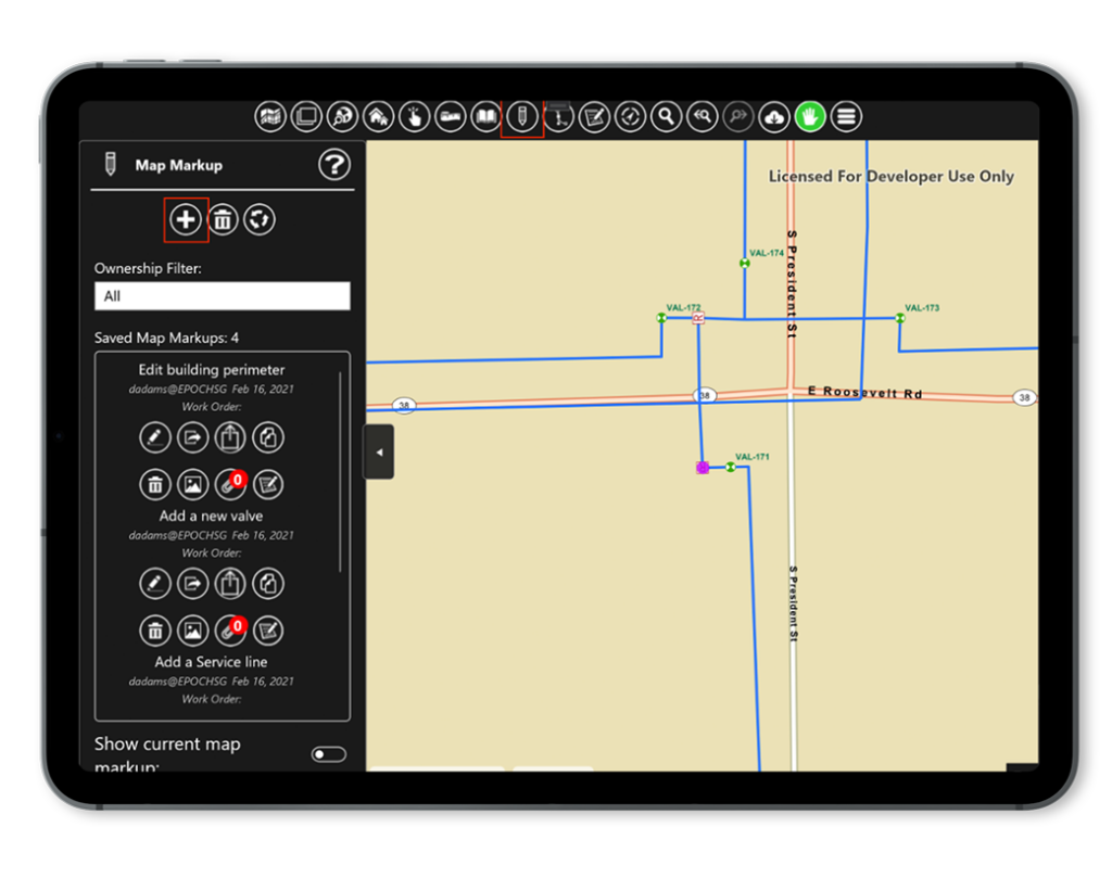
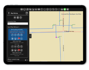
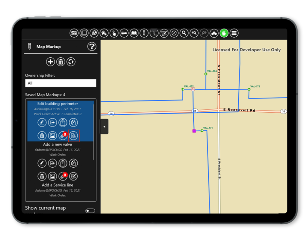
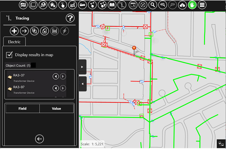
At Epoch Solutions Group, we have supported an optimized offline connected model and tracing for many years. Three main factors led us to this decision that is the driving factor of this post. Our product, EpochSync, used for cross-platform spatial data integration for technologies such as Smallworld and Hexagon G/Technology, will now be integrated into the EpochField platform. There have been many discussions recently regarding Esri’s Utility Network, its capabilities, and how it can be utilized in a mobile solution, and I would like to address some factors in this topic.

  • Many of our Esri-based customers are still in the process of transitioning from geometric network to utility network and still need that tracing experience in the field today. The tracing extract functionality within EpochField Data Preparation Server has connectors for both Geometric Network and Utility Network. We can deploy offline network tracing to the field fed by the geometric network and switch very easily to the utility network. Once the transition happens in the enterprise GIS with no changes to the field, apart from the different schema necessitated by the utility network.
  • Utility Network is still not available offline, so any solution that utilizes this is severely limited in low or zero cellular coverage areas. Offline tracing through the EpochField Mobile network model continues with zero interruption.
  • Many of our customers utilize other GIS Platforms such as Smallworld and Hexagon as their system of record. EpochSync, which is now part of the EpochField solution, can handle the synchronization of network connectivity data straight into the EpochField Mobile network model. With the plugin architecture of EpochSync Pro, additional data sources can easily be customized to integrate other network connectivity models. This also adds additional capabilities to the EpochField Mobile solution, such as the ability to view Smallworld Internal Worlds, which has been somewhat of a mystery to other mobile solutions.
Network Tracing with EpochField Mobile

All in all, implementing a geospatial enabled mobile solution with tracing is often not just a simple question of “does it do network tracing?” There are many factors in how the solution meets both the business requirements and integrates with the existing enterprise architecture seamlessly and with a future roadmap. Utility network is absolutely part of ours but only when it is part of yours.

Schedule a demo to learn more about EpochField’s network tracing capabilities and how they can work for you.

Just Released: EpochField 4.3.5

Epoch Solutions Group is excited to announce that the release of EpochField 4.3.5 is now available in mobile app stores for both Android and iOS and an install package for Windows 10 (UWP). EpochField is a complete, end-to-end multi-platform workforce management solution designed for both back-office work management and field crews to strategize, plan, and execute utility workflows in a map-centric, disconnected, real-time environment.

EpochField 4.3.5 is a minor follow-on to the previous 4.3.4 EpochField release. It continues to build on and strengthen the capabilities of 4.3.x EpochField in several key areas of the software and user experience.

For 4.3.5 to work as expected, please ensure the version alignment for your EpochField Suite is as follows:

  • EpochField Mobile 4.3.5
  • EpochField Workflow Builder 4.3.2
  • EpochField Work Management Server 4.3.2
  • EpochField Work Scheduler 4.3.3
  • EpochField Data Preparation Server 4.3.1

What’s New:

Synchronization of work order tables and work order features happens bi-directionally. This includes all work tables, including attachments which can become extremely large. There is a new EpochField Mobile application configuration boolean parameter under the <WorkManagementToolSettings> tag called.  If this is omitted from the application configuration, the behavior defaults to false (current behavior, which is bi-directional attachment sync).  Set it to true, and the work management replica geodatabase is created with the option to only upload attachments set, so attachments created by others are not downloaded. The usage is as follows: 

.. 

.. 

    true 

.. 

Issues addressed in this update:

Bugfix #21493: This is a product enhancement that allows the user to save their layer visibility settings on a portal group level between application sessions. Settings are saved to the device and can be removed if the user chooses to. To save the layer visibility settings, the user can tap on a “Save” button on the Operational Layers Tool UI. These saved settings are removed from the device when the application is uninstalled.

Bugfix #24499: The animation behavior of the GPS symbol on the map can cause a spike in GPU activity, adversely affecting the usability of EpochField Mobile. To address this problem, we have added a configuration setting to the application configuration. Set the value to false to disable the animation behavior:

..

    false

..

Bugfix #24821: Prior to this fix, EpochField Mobile for UWP could not be downloaded for offline install from the Windows Store, which is a requirement for some customers who distribute the app through their own MDM.

Bugfix #25187: This fix addressed a problem with the Click Integration toowhere no matter which asset in a selection list is checked/selected for passing to ClickMobile, only the first asset in that list is sent.

Bugfix #25456: In short, electric tracing was broken. We fixed it.

Bugfix #25598: While trying to route from an asset on the map from the Identify results user interfacewhen using an external routing application, it throws an error message to the user. It would first display the error message about the Address Search not being enabled, with no additional information in the log.  A second route search on a nearby asset does not throw the error a second time.

You’ll find EpochField 4.3.5 in the App Store and Google Play today, or contact us at:
720-458-3006 or sales@epochsg.com

EpochField as a Service – A New Offering

As part of our next major release for EpochField, we are moving to a new offering in the way of SaaS. As part of this article, I’d like to address some of the industry trends that have led us to this decision and an exciting new chapter for EpochField and our existing and new customers.

EpochField integrates with multiple back-office IT systems such as GIS and Enterprise Asset Management (EAM). This integration becomes even more critical now that EpochField 5.0 supports scheduling and dispatch with Work Scheduler. These IT systems invariably are deployed on-premise with customizations to support the utility’s unique business processes. Together with the practice of certain accounting rules, it was a natural decision for us to launch EpochField supporting this on-premise model of implementation. With this model, after implementation, the utilities IT team would take over day-to-day support of EpochField and have complete autonomy of the environment to be successful with the architecture.

However, one of the significant drawbacks to the on-premise model has been the impact on the support team. Software vendors continue to evolve their products which for Epoch is two major releases per year, and taking into account some of the other major back-office system upgrades taking 1-3 years and migrations in virtual hardware infrastructure, the utilities IT staff is completely consumed upgrading and replacing all these systems.

So, how do we free up these IT resources to focus on non-support items and internal innovation and increase their bandwidth? There are lots of reasons for a software vendor choosing SaaS as a deployment strategy for its products. Still, it is why it is valuable for our customers, which is the primary driving factor here at Epoch.

  • A SaaS architecture allows the utility to evolve with the latest new features in quick iterative releases and, through the automation factor, relatively cheap to test and deploy.
  • SaaS vendors provide automated patch releases and upgrades across all the products. This needs to be done seamlessly to the business and efficiently, especially when dealing with geographically and intermittently connected field personnel. This in itself is a huge time saver for internal IT personnel.
  • A large part of the business we support with utilities is dependent on seasonal processes and events. For example, subcontracting a large pole inspection project for the spring/summer in a climate that has major ground freezing or mutual aid crews being enabled in the event of a major hurricane. Through a SaaS architecture, the licensing and scaling on the solution are automatic and metered, so you only pay for what you need and, therefore, no need to overprovision. Imagine the scaling of internal architecture for that once-in 2-year event that may hit your service territory. This factor is probably one of the most significant selling points of cloud solutions.
  • For a utility trying to attract new talent, legacy/aging infrastructure is probably the most significant factor in losing good internal IT talent. With SaaS, it leverages modern software tools and practices but also allows the internal talent to work on new and innovative internal projects.
 

In summary, SaaS takes away the cost and mundane tasks that running on-premise software has. It also forces good software practices and helps enforce configuration over customization, which is the path of destruction for many utilities. We often say that utilities all do the same thing but differently. SaaS helps enforce best practices.

As a final point, while SasS will become an offering that we feel will benefit customers, we will continue to offer on-premise implementations to support customers whose internal policies need it. The improvements we are planning in EpochField architecture will benefit even these implementations.

Just Released: EpochField 4.3.4

Epoch Solutions Group is excited to announce that the release of EpochField 4.3.4 is now available in mobile app stores for both Android and iOS and an install package for Windows 10 (UWP). EpochField is a complete, end-to-end multi-platform workforce management solution designed for both back-office work management and field crews to strategize, plan, and execute utility workflows in a map-centric, disconnected, real-time environment.

EpochField 4.3.4 is a minor follow-on to the previous 4.3 EpochField release. It continues to build on and strengthen the capabilities of 4.3.x EpochField in several key areas of the software and user experience.

For 4.3.4 to work as expected, please ensure the version alignment for your EpochField Suite is as follows:

  • EpochField Mobile 4.3.4
  • EpochField Workflow Builder 4.3.2
  • EpochField Work Management Server 4.3.2
  • EpochField Work Scheduler 4.3.3
  • EpochField Data Preparation Server 4.3.1

Issues addressed in this update:

Bugfix #24575: Category list scrolling in Workflow forms was broken. For long category lists, if you scrolled down to the bottom of the list and selected a category, then chose a value, the category list would ‘snap’ or ‘jump’ back to the top unexpectedly, causing some confusion about what the user was seeing. This has been fixed.

Bugfix #24867: While using an Android device and collecting Map Markup information, the barcode/QR scan button would crash EpochField when it was pressed. This has been fixed and the barcode/QR scan functionality now works as expected running EpochField on Android.

You’ll find EpochField 4.3.4 in the App Store and Google Play today, or contact us at 720-458-3006 or wes.clain@epochsg.com

How to Use an External GPS Device in EpochField

EpochField is configurable to use GPS external to the device on which you are running the app. You may want to do this if your device does not have an internal GPS or if its native GPS is not precise enough, or for some other reason. On Windows, this can be done by configuring the app to get its GPS data from a serial port; on iOS or Android, and you will need to configure your device’s location manager to use the external GPS device. This article covers how to configure external GPS devices to work in these scenarios with EpochField Mobile.

GPS Data from Serial Port (Windows)

A common type of external GPS device is one that connects via Bluetooth. Once paired, your Windows machine will assign virtual COM ports to this device which EpochField may be configured to connect to.

How to Use an External GPS Device in EpochField

Getting the COM Port

On Windows 10, open “Bluetooth & other devices,” go to “More Bluetooth options,” and select the “COM ports” tab. From here, you can see which port to use for GPS in EpochField.

Configuring EpochField to use Serial GPS Data

Once you have found the port, you need to configure EpochField to use serial data for GPS. In your ApplicationConfig.xml file, go to GPS settings and set the following parameters.

<UseGPSDevice>0</UseGPSDevice>
<GPSComPort>COM3</GPSComPort>

GPS device 0 tells EpochField to get its GPS data from a serial port. COM3 is the port from which to read the data. This will be whatever COM port your GPS device is using. If you get the port wrong, EpochField will attempt to find the correct port. If it fails to find the port, the app will notify you.

Once connected to the GPS device, if the device is functioning correctly, you will see EpochField using the data it gets from the device. If it is not working correctly, see “Using the Correct GPS Data” below.

“Using the Correct GPS Data” below. GPS Data Via Your Device’s Location Manager (Android or iOS)

On Android or iOS, you can have the external GPS take over your device’s location manager. Once you have accomplished this, there is no need to configure EpochField, as it will already be using your device’s location manager by default.

Using the above example of a Bluetooth GPS device, once you have paired the external GPS with the device running EpochField, you will need to download an app that allows you to “mock” GPS with an external device. On Android, the “Bluetooth GNSS” app is an option, but there are many others available.

Assuming we are using Bluetooth GNSS, open Settings on your device and enable Developer Options; from there, change ‘Set Mock Location App’ to “Bluetooth GNSS”. Open the Bluetooth GNSS app, select your external device as the target, and hit Connect. You should soon see data coming in from the device. If you do not, see “Using the Correct GPS Data” below.

How to Use an External GPS Device in EpochField

Using the Correct GPS Data (All devices)

If you are not getting any data from the device after doing the above, it is possible the device is not configured to send you the correct data. Many devices have free apps from the manufacturer that allow you to configure the device. Using a Trimble device as an example, we downloaded the GNSS Status app which was available on all platforms (Windows, iOS, Android). In this app, we opened the Source tab and selected all NMEA data. Once we did this, the data we needed from the device began streaming in.

Written by:
Jon Ruland – Software Engineer

How to Associate Map Markups with Work Orders

Fieldwork often involves adding sketches, text blocks, and other various redlining elements to a digital map in the field while completing assigned work orders. These sketches, also referred to in the EpochField product ecosystem as “map markups,” bring valuable sources of ground truth from the field to the back-office, maintaining currency and accuracy in an organization’s work management system.

One of the significant challenges in collecting and storing map markup drawings is knowing the answer to this question:

Do these map markups have a spatial and/or business relationship to a particular work order, and if so, which one?

EpochField Mobile addresses this challenge. When a user in the field selects a work order to fulfill, a map markup, new or existing, can be linked to that current work order. The relationship then persists throughout the lifecycle of the work order. This becomes extremely useful in analytics and reporting, both visually and geographically.

This article covers a use case where a field worker completes a work order and finds the need to add information to it using the Map Markup tool. The map markup tool in EpochField Mobile is used for capturing map markup elements drawn on the map while either offline or connected to a network that can be synchronized to the back-office database

Configuring EpochField Mobile to honor the Map Markup and Work Order relationship

A specific element needs to be added to the application configuration for this linking functionality to work. The app configuration needs the tag set to true in the MapMarkupToolSettings parent element.

How it works

The user works in a selected work order and decides that a map markup diagram is needed to complete the work order.

How to Associate Map Markups with Work Orders

The user will select the Map Markup Tool on the toolbar and complete all map edits with the Map Markup Tool.

How to Associate Map Markups with Work Orders

The user will click the associate button on the main Map Markup List.

How to Associate Map Markups with Work Orders

The Selected Work Order shown on the bottom of the map is then associated with that Map Markup.

How to Associate Map Markups with Work Orders

The user can associate as many Map Markups with a Work Order as desired. However, a Map Markup can only be associated with a single Work Order. Users can disassociate the Map Markup by clicking the Disassociate button. This removes the reference to the selected work order from the Map Markup record.

How to Associate Map Markups with Work Orders

Establishing and managing relationships between Map Markup drawings and work orders is easy and intuitive using EpochField Mobile.

Written by:
Eric Bader – Product Manager
David Adams – Software Engineer