How to Use an External GPS Device in EpochField

EpochField is configurable to use GPS external to the device on which you are running the app. You may want to do this if your device does not have an internal GPS or if its native GPS is not precise enough, or for some other reason. On Windows, this can be done by configuring the app to get its GPS data from a serial port; on iOS or Android, and you will need to configure your device’s location manager to use the external GPS device. This article covers how to configure external GPS devices to work in these scenarios with EpochField Mobile.

GPS Data from Serial Port (Windows)

A common type of external GPS device is one that connects via Bluetooth. Once paired, your Windows machine will assign virtual COM ports to this device which EpochField may be configured to connect to.

How to Use an External GPS Device in EpochField

Getting the COM Port

On Windows 10, open “Bluetooth & other devices,” go to “More Bluetooth options,” and select the “COM ports” tab. From here, you can see which port to use for GPS in EpochField.

Configuring EpochField to use Serial GPS Data

Once you have found the port, you need to configure EpochField to use serial data for GPS. In your ApplicationConfig.xml file, go to GPS settings and set the following parameters.

<UseGPSDevice>0</UseGPSDevice>
<GPSComPort>COM3</GPSComPort>

GPS device 0 tells EpochField to get its GPS data from a serial port. COM3 is the port from which to read the data. This will be whatever COM port your GPS device is using. If you get the port wrong, EpochField will attempt to find the correct port. If it fails to find the port, the app will notify you.

Once connected to the GPS device, if the device is functioning correctly, you will see EpochField using the data it gets from the device. If it is not working correctly, see “Using the Correct GPS Data” below.

“Using the Correct GPS Data” below. GPS Data Via Your Device’s Location Manager (Android or iOS)

On Android or iOS, you can have the external GPS take over your device’s location manager. Once you have accomplished this, there is no need to configure EpochField, as it will already be using your device’s location manager by default.

Using the above example of a Bluetooth GPS device, once you have paired the external GPS with the device running EpochField, you will need to download an app that allows you to “mock” GPS with an external device. On Android, the “Bluetooth GNSS” app is an option, but there are many others available.

Assuming we are using Bluetooth GNSS, open Settings on your device and enable Developer Options; from there, change ‘Set Mock Location App’ to “Bluetooth GNSS”. Open the Bluetooth GNSS app, select your external device as the target, and hit Connect. You should soon see data coming in from the device. If you do not, see “Using the Correct GPS Data” below.

How to Use an External GPS Device in EpochField

Using the Correct GPS Data (All devices)

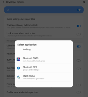
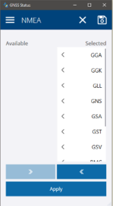
If you are not getting any data from the device after doing the above, it is possible the device is not configured to send you the correct data. Many devices have free apps from the manufacturer that allow you to configure the device. Using a Trimble device as an example, we downloaded the GNSS Status app which was available on all platforms (Windows, iOS, Android). In this app, we opened the Source tab and selected all NMEA data. Once we did this, the data we needed from the device began streaming in.

Written by:
Jon Ruland – Software Engineer

How to Associate Map Markups with Work Orders

Fieldwork often involves adding sketches, text blocks, and other various redlining elements to a digital map in the field while completing assigned work orders. These sketches, also referred to in the EpochField product ecosystem as “map markups,” bring valuable sources of ground truth from the field to the back-office, maintaining currency and accuracy in an organization’s work management system.

One of the significant challenges in collecting and storing map markup drawings is knowing the answer to this question:

Do these map markups have a spatial and/or business relationship to a particular work order, and if so, which one?

EpochField Mobile addresses this challenge. When a user in the field selects a work order to fulfill, a map markup, new or existing, can be linked to that current work order. The relationship then persists throughout the lifecycle of the work order. This becomes extremely useful in analytics and reporting, both visually and geographically.

This article covers a use case where a field worker completes a work order and finds the need to add information to it using the Map Markup tool. The map markup tool in EpochField Mobile is used for capturing map markup elements drawn on the map while either offline or connected to a network that can be synchronized to the back-office database

Configuring EpochField Mobile to honor the Map Markup and Work Order relationship

A specific element needs to be added to the application configuration for this linking functionality to work. The app configuration needs the tag set to true in the MapMarkupToolSettings parent element.

How it works

The user works in a selected work order and decides that a map markup diagram is needed to complete the work order.

How to Associate Map Markups with Work Orders

The user will select the Map Markup Tool on the toolbar and complete all map edits with the Map Markup Tool.

How to Associate Map Markups with Work Orders

The user will click the associate button on the main Map Markup List.

How to Associate Map Markups with Work Orders

The Selected Work Order shown on the bottom of the map is then associated with that Map Markup.

How to Associate Map Markups with Work Orders

The user can associate as many Map Markups with a Work Order as desired. However, a Map Markup can only be associated with a single Work Order. Users can disassociate the Map Markup by clicking the Disassociate button. This removes the reference to the selected work order from the Map Markup record.

How to Associate Map Markups with Work Orders

Establishing and managing relationships between Map Markup drawings and work orders is easy and intuitive using EpochField Mobile.

Written by:
Eric Bader – Product Manager
David Adams – Software Engineer