Get a Demo

Epoch Solutions Group Blog

EpochField 5.2.6 Release

What's New in EpochField 5.2.6

We’re pleased to announce the release of EpochField 5.2.6. The following highlights all of the items addressed.

Bug Fixes

ID Title
CS-477 Work Management - Adding work features by lasso is not working
N/A Can't Route to Asset from Identify Tool
N/A Flash functionality inconsistencies - Flash Geometries in wrong place on first load

EpochField 5.2.5 Release

What's New in EpochField 5.2.5

We’re pleased to announce the release of EpochField 5.2.5. The following highlights all of the items addressed.

Bug Fixes

ID Title
N/A GPS Icon: "Regular GPS" versus "Follow Me"
N/A GIS Landbase Basemap: grids/tiles/squares in the background
N/A Work Management: Option selection highlight is very faint (WinUI/Android)
N/A Apply better Preview and Check Mark icons in Print Area
N/A Fix Maintenance Script to work with the new State Model Schema
N/A Flash functionality inconsistencies - Flash button not enabling

EpochField 5.2.4 Release

What's New in EpochField 5.2.4

We’re pleased to announce the release of EpochField 5.2.4. The following highlights some of the new features available.

Product Highlights

Edit Multiple Work Features Tool Enhancement
The ‘Edit Multiple Work Features’ tool has been enhanced to allow field workers to draw a lasso/polygon by selecting points on the map for each vertex and closing the polygon by double-clicking/tapping on the final vertex. This precise selection method is critical for accurately managing tasks and bulk editing work features. The enhancement ensures the tool functions consistently with other polygon-drawing features in the EpochField platform, such as the WorkOrderPolygon.

Key Features:

  • Vertex-Based Polygon Drawing: Users can now add vertices by clicking on the map and close the polygon by double-clicking/tapping on the final vertex, allowing for a precise selection of work features.
  • Configuration Settings:
    • This new feature is configurable through the <WorkManagementToolSettings> node in the application config. Add <LassoToolMode>Vertex</LassoToolMode> to set the lasso to “vertex” mode. Valid values for this setting are:
      • Freehand
      • Vertex
  • This enhancement provides a more intuitive and precise way for field workers to manage their tasks, ensuring they can select and edit work features accurately and efficiently.
    • Enhanced Printing Functionality
    • App Icon Updates

Enhanced Workflow Form Flexibility
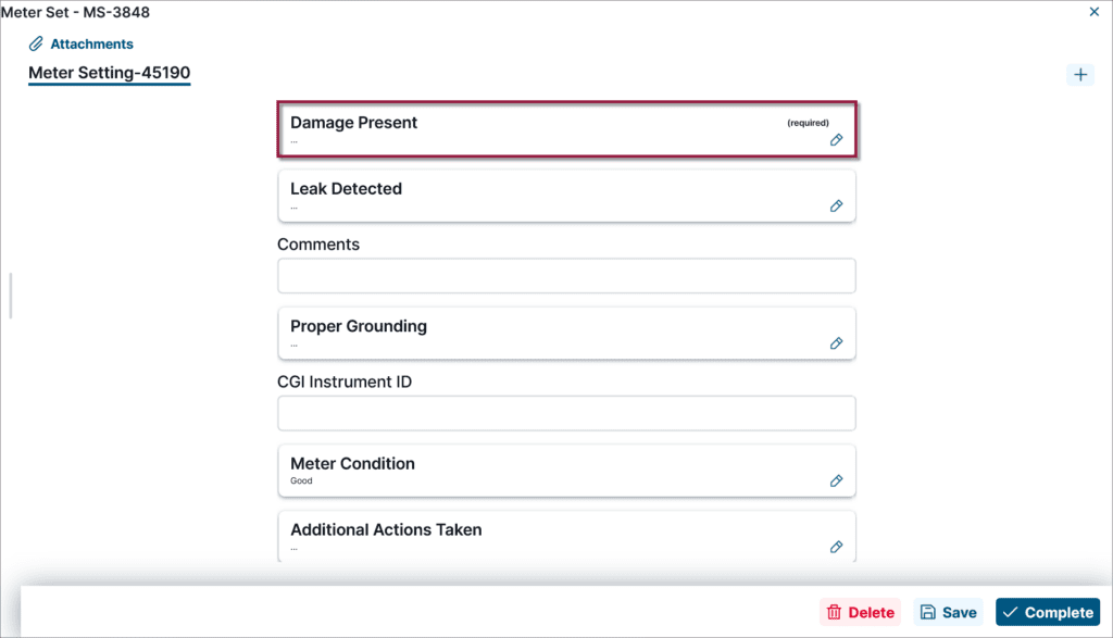
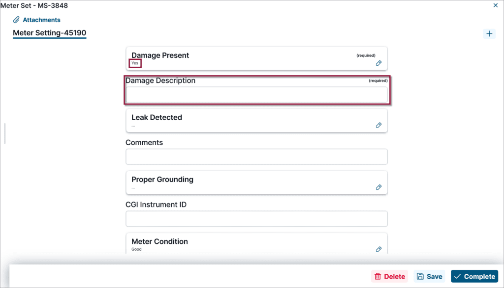
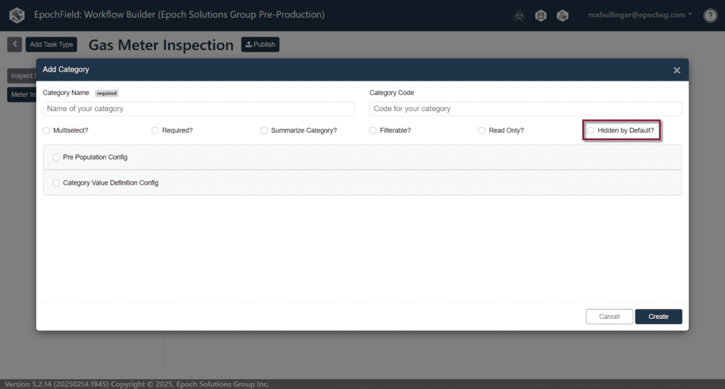
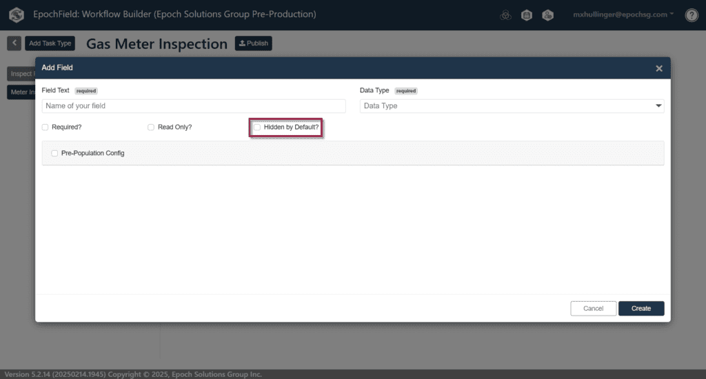
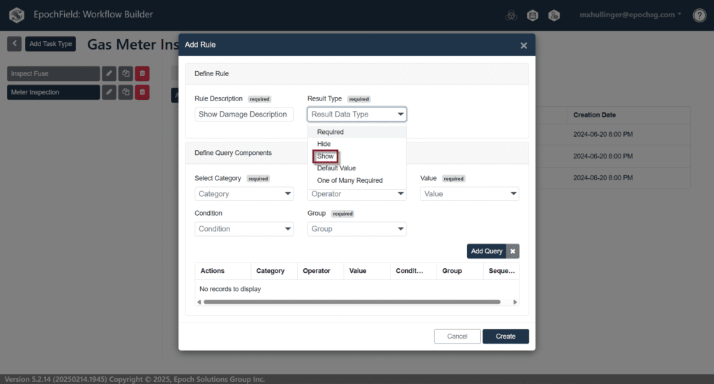
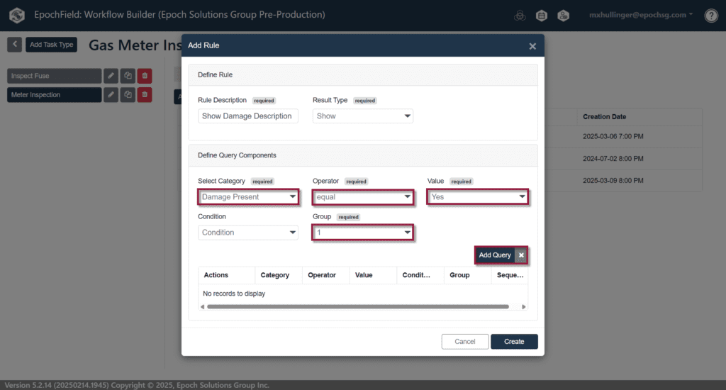
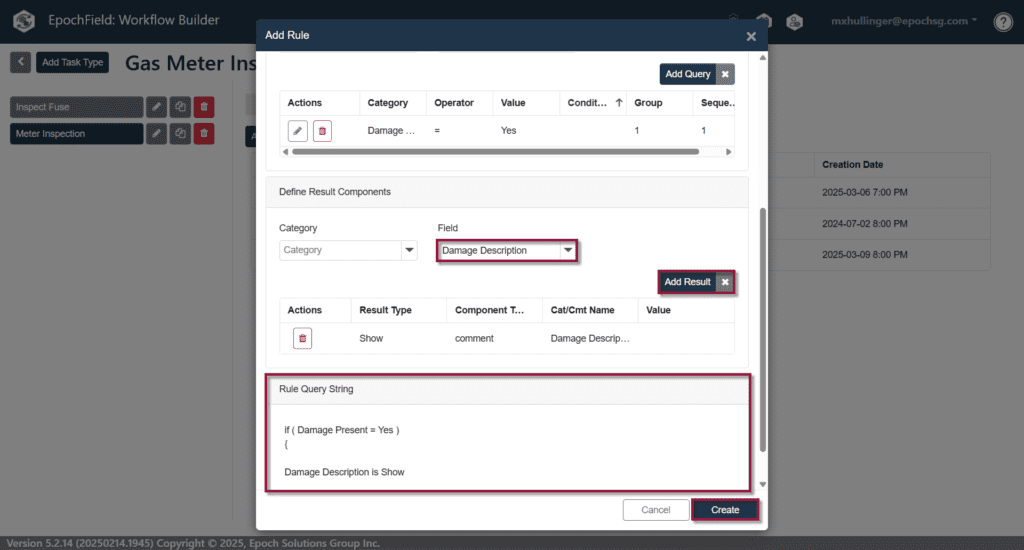
We have updated the Workflow Forms to allow Categories and Fields to be intermixed on the same form. Previously, single-select and multi-select options were in one section while fields for manual data input were in another, which was not conducive to how field workers complete forms. The new layout guides field workers through the form in a logical order, eliminating the need to hunt and choose fields, and Workflow Builder enables the creation of these forms using a drag-and-drop interface. Additionally, with this new approach, fields can be hidden as desired using Intelligent Workflow, reducing confusion and making the process more efficient for field workers.

Enhanced Edit Work Features Functionality
We have introduced a significant enhancement to the “Edit Multiple Work Features” lasso functionality. With this update, field workers can now see a list of all lassoed work features displayed on the left panel before the main form opens. This side panel allows users to view, select, or deselect work features for editing, providing better oversight and management.

Users can choose to edit individual features or apply changes to all lassoed work features at once, improving both efficiency and accuracy in task completion. This update streamlines workflows and offers greater flexibility when handling multiple work features. This enhancement provides a more controlled and flexible approach to editing multiple work features, ensuring users can manage their tasks more effectively.

Delete Work Features Directly from Forms
We have added the ability for field workers to delete work features directly through the main form. This enhancement also supports bulk deletion, allowing users to efficiently remove multiple work features at once, either through the main form or the pop-up form. This update simplifies the deletion process, making it more convenient and flexible for field workers to manage work features.

Bug Fixes

ID Title
Various Various bug fixes found internally that were not experienced by any customers.
CS-233 Android and iOS: Text is cutoff in the identify panel
CS-237 Epochfieldworkmgmt.exe fails to obfuscate text (required for install configuration)
CS-284 Active Work Order tool layout is not good - Click Classic
CS-296 Clicking on an Attribute table shows smaller table than originating side panel
CS-321 EpochField 5.2 SB - Location Services Required to be Enabled
CS-322 EpochField 5.2 SB - Identify, Attribute Table Visibility
CS-323 EpochField 5.2 SB - GPS Functionality Issues
CS-327 EpochField 5.2 SB - Tracing
CS-328 Must choose different tool to close hamburger menu
CS-336 EpochField 5.2 SB - Attribute Tables relationships appear incorrect
CS-337 EpochField 5.2 SB - Identify Tool Duplicates
CS-380 Send to Click Tool is failing in Click
CS-382 Portal User Maint ignores new users that have not yet logged in
CS-392 Assignment in InboundQueue does not update the state_id for the epochfieldscheduleitem table
CS-393 Work Tasks is deletable when the task type is configured not to be deletable
CS-400/406 _tickle_related_records should not have any business logic in it other than tickling the records

How the Esri Utility Network Transforms Utility Data Management

EpochSync Pro Facilitates Migrating Data to this Powerful Network

As utilities grapple with escalating challenges in a complex and dynamic environment, many are looking to solutions like the Esri ArcGIS Utility Network to simplify data management while ensuring integrity, even across massive data sets.

“Throughout our 15-year relationship with Esri—and now as an Esri Gold Partner—we’ve worked together to identify and solve utilities’ needs, especially by integrating Esri technology with our own suite of solutions,” noted James Street, Epoch Solutions Group CEO. “With the need to manage and integrate data becoming both more challenging and more critical for utilities, we see great value in helping our customers leverage powerful tools like the Esri Utility Network.”

We recently tapped Esri Product Manager Saranya Kesavan to share insights on how the company’s next-generation ArcGIS Utility Network is helping to improve data management amidst transformative change.

New Challenges Make Data Management Vital

Grid modernization has become a high priority across the utility industry, especially as electricity demand rises in response to the shift to clean energy, increased electric vehicle adoption, and a rise in data center power usage to support cloud-based applications. The increase in electricity demand is redefining the power load and tasking utilities with improving energy supply and reliability, according to Kesavan.

“It’s all placing a lot more demand on the grid,” she said. At the same time, climate change is fueling more frequent and severe storms, resulting in more power outages that require utilities to respond quickly and efficiently and maintain high customer satisfaction.

“Challenges like these make a utility’s network more mission-critical than ever, while making data management essential yet more difficult,” Street pointed out. As utilities strive to improve this function, many are moving to the Esri ArcGIS Utility Network.

Setting the Foundation

The ArcGIS Utility Network serves as a system of record that captures data on all utility assets in detail, ensuring that any applications built on the platform can readily access the data required. According to Kesavan, Esri’s network management solution as it is today has evolved over the last 20 years in lockstep with technology advancements.

“Esri’s initial geometric network was robust at the time, but the technology and the industry have changed significantly,” she said. The then-current technology which the network was built on presented inherent limitations, particularly at a time when utilities often maintained data in multiple, disparate applications that didn’t provide a holistic view or enable access to timely, accurate information.

“For example, field crews often lacked real-time information about changing conditions, especially data from downstream applications like their outage management system,” she explained.

As both the technology and the industry’s needs evolved, the Esri network did too. “We considered how utilities are now organizing their data, the workloads they’re managing, and how to future-proof the model,” Kesavan said. With the retirement of Geometric Network, Esri created a next-gen utility network on the ArcGIS Pro mapping and visualization platform.

Integrity, Scalability, and Productivity Top the List

Esri built its new ArcGIS Utility Network to address three common and interrelated needs of today’s utilities: data integrity, network scalability, and network management productivity.

“By using a services-oriented network, utilities can spend less time on tasks like controlling who can access and edit data, improving productivity without sacrificing data integrity or security,” Kesavan said. At the user level, the network restricts data access based on login credentials, while at the network level, rules fire off dynamically as data is edited, triggering error messages that reduce the odds of inputting bad data.

“The network rules can control what type of transformer can connect with what type of conductor,” she explained. “The goal is to ensure the Utility Network is robust and stable, and that it identifies any workflows with potential to corrupt the organization’s data set.” With data volumes growing rapidly within most utilities, the highly scalable network is designed to reduce the strains of day-end processing, ensuring data is clean, up to date, and pushed out to every downstream application, even when large volumes are involved.

The Esri ArcGIS Utility Network also facilitates moving from manual workflows to automated workflows that speed and streamline work, improve accuracy, and leverage the value of digitized data. “For example, rather than draw up a rough sketch of a field installation and send it to GIS team, field crews can capture that information digitally,” Kesavan said.

Managing data in a dynamic environment demands that the utility’s staff has a clear, accurate view of what’s happening in the field at all times. Esri’s Utility Network aims to provide that view through a highly detailed network model and built-in visualization tools that remove visual clutter while keeping data within reach. “Each user can choose the level of detail they need to see,” she said, while authorization measures ensure data security.

Additionally, end users and system administrators can utilize dashboards with embedded awareness of the utility network topology and associations. “Utilities are customizing these dashboards to gain a better understanding of what’s happening in their network at any given time, through a single system of record,” Kesavan explained. The more applications integrated, the more holistic the view. “That enables utilities to identify trends, gather insights, develop mitigation plans to solve problems, and work proactively to prevent them.”

Solving the Dilemma of Getting Data Into the Network

One of the impediments to using the Esri Utility Network is the challenge of migrating data from GE Smallworld Version Managed Data Stores and other GIS databases that store utility transmission and distribution GIS data. Since the data models involved vary significantly, it isn’t always easy to port the data over.

“As more utilities look to leverage the Esri Utility Network for map-based applications like emergency operations management, outage management, and streetlight management, we recognized that the data migration need was becoming more pressing,” Street said.

That’s why Epoch Solutions Group developed EpochSync Pro, a GIS data migration software tool that simplifies the migration of GE Smallworld data to Esri. EpochSync Pro helps utilities harness the full power of the Esri ArcGIS Utility Network by providing a seamless way to synchronize data bidirectionally and accurately between Smallworld Version Managed Data Stores and Esri ArcGIS Enterprise Geodatabases, even for large data volumes. “We specifically wrote this tool in the ArcGIS Pro SDK to fully leverage the value of the network and the ArcGIS functionality on behalf of our utility customers,” Street said.

EpochSync Pro is part of the Epoch Solutions Group suite of solutions, helping utilities leverage the power of GIS data to transform field operations. Contact Epoch Solutions Group to schedule a demo of EpochSync Pro, or contact Esri to schedule a demo of the Esri ArcGIS Utility Network.

EpochField 5.2 Release

What's New in EpochField 5.2

EpochField 5.2 introduces new features for data management and administration along with an enhanced user interface, including support for phone format devices. In addition, it migrates the mobile application to the .Net Maui framework to follow some recent Apple App Store compliance issues related to iOS 17 support with the Xamarin framework. A number of bug fixes and performance improvements have also been implemented in both the EpochField Web Suite and EpochField Server components.

The following highlights some of the new features available at 5.2.

Product Highlights

  • Work Management Enhancements: As part of our support for vegetation management workflows, we have made some significant improvements to the work management tool:
    • Streamlined Workflows: Enhanced data collection capabilities simplify processes, reducing administrative time by simplifying data entry and facilitating efficient editing, bulk creation, and deletion of features.
    • Improved Data Accuracy: Enhanced features ensure precise data entry, minimizing errors in records. Personalized work feature filters help tailor data management to specific needs.
    • Enhanced Field Worker Efficiency: Tools like auto-populating form categories and customizable work order filters optimize field worker productivity. Optimized user experience on Toughbooks with stylus support enhances usability in the field.
  • Redesigned Mobile UI/UX
    • Mobile Interface Redesign: Modern and intuitive design for enhanced usability.
    • Engaging Experience: Improved interface boosts productivity and simplifies interactions.
    • Intuitive Navigation: Easy-to-use design for seamless navigation and understanding.
    • Increased Efficiency: Streamlined workflows promote faster task completion.
    • Simplified Interactions: Reduced complexity for improved usability.
  • WMS Inbound Queue Optimization
    • Improved Performance and Stability: Enhancements boost system efficiency and stability.
    • Streamlined Operations: Optimized processes ensure smoother workflow execution for enhanced productivity.
    • Minimized Disruptions: Identified and resolved bottlenecks in the WMS Inbound Queue to minimize work management disruptions.
  • Self-Managed Work Order Process Improvements
    • Work Order Task Upload: A large part of utility field work involves workers planning their own work in the absence of enterprise-driven work order creation. Field workers can initiate ad-hoc work orders and upload CSV lists of assets for completing assignments, such as routine inspections, within EpochField Mobile.
  • Work Order Status Visibility Enhancement
    • Enhanced Visibility: Provides unified visibility into work order statuses for improved operational oversight.
    • Shared View: Ensures all stakeholders have a common, near real-time view of work order statuses.
    • Configurable Status Flow: Provides ability to define statuses and allowed status transitions between statuses on work orders to promote controlled workflows and align with outside systems.
  • Esri ArcGIS Enterprise 11.1 Support
    • Compliance with Esri ArcGIS Enterprise 11.1 software, aligning the platform with industry standards and providing users access to the latest geospatial capabilities.
  • .NET Maui Migration
    • Future-Proof Development: Establishes a solid foundation for future cross-platform mobile development.
    • iOS 17 Support: Migration to .NET Maui addresses recent Apple App Store compliance issues related to iOS 17 support.

Bug Fixes

ID Title
30727 Workflow Form: Navigation button enabled even though there is nowhere to navigate
30823 Omni-present Identify Tool does not reactivate once deactivated
30892 Map Markup: Editing a map markup feature comment appears buggy on iOS
30897 Login button remains active on a fresh install when the application is offline
31069 Inconsistency with the required indicator on the workflow UI
31706 Address search routing needs improvement in UI
31777 Map Markup Attachment view is too large
31926 Support for Composite Locators needed
32249 Rename the title of the Sort Work order filter to: "Choose and order fields to sort by:" from "Choose up to 3 fields to sort by"
32329 When a work order filter is enabled and group visibility is managed, the filter shows as active but is not
32360 Work order filters not functioning consistently
32399 Mobile: Map markup attachments with long names cover the delete button
32407 Work Calendar: Scheduled equipment doesn't display unit number in the resource name
32413 Opening a Work Order without editing causes users to become "stuck"
32414 Print Options: "Map Only" and "Header and Footer" produce the same result
32415 Worker calendar: "Add title" text defaults for an unnamed resource at a specific time
32435 Asset Query Screen: Filtering on date fields fails to generate a workable query
32440 Unable to enlarge Gantt chart in version 5.1
32455 PDF attachment doesn't work when added from Mobile and opened in Work Scheduler
32460 Adding attachment to a work order in Work Scheduler results in inability to open attachment on mobile
32508 Scroll Bar covers buttons
32567 Groups/Roles Currently Assigned are not populating
32570 Assets tab not visible when clicking to View an SDS Work Order
32658 Work Order Dialog: Input validation on existing WO throws a message
32672 Fixing file already exist error
32673 Table EPOCHFIELDUSER creates a new user record every time it goes to the portal
32674 Selecting address suggestions fails to actually select the suggestion
32683 Issues with Sync Fusion controls for iOS and Android
32888 Mobile: Version 5.2 crashes in EFRelationship in models
33042 Omni present tool bug on Google Street View and tracing tools
33072 Unable to create a new worker in Resource Management
33137 Caching Base Workspace Names takes over an hour
33140 Several functions in WMS take several minutes to run or more
33142 Running WMS generates a bunch of empty log files for each tool
33146 Log file purges delete everything in the log folder, not just old logs
33380 enable_archiving_attachments.py script is broken
33526 Remove portal maintenance from WMS
33578 Database after running Archiving/Attachments is missing some views
33581 Work Order List/Filtering Gantt: Issues with colors
33623 EF Data Class doesn't default schema to configured value
33833 Saving color in Schedule Item type saves an "ff" at the end of the hex
33892 Weird and intermittent messages related to out of memory exception while downloading a package more than 200 MB
34087 Gantt Filter doesn't change colors as expected when filtering
34091 Creating child work order from Gantt is inconsistent
34455 Work Scheduler freezes when map configuration to ESRI is not correct
34486 Work management views loading bug
34917 State model processes take a long time to load
34918 Errant character "<" in Processes page
34919 Save Process button
34921 Not able to add states with a hyphen
34923 Should not be able to save a process without transitions
34924 Left align the Process cards
34926 Validation of transitions is too much
34963 Large space between tabs and Event log grid
35014 Data Prep has incorrect scripts for EPOCHFIELDLOG and does not contain EPOCHFIELDSCHEDULEITEMVIEW
35064 Should not be allowed to copy a Schedule Item Process type
35065 Clicking copy on process card creates 2 copies
35067 States are not copied correctly when copying a process
35088 Word Order ID overlaps buttons when adding User History in ad-hoc work order
35091 Duplicate process name validation does not clear
35092 Can't tell which states are duplicate
35093 Copying processes naming is weird
35094 Certain states are required so different products can function
35095 Sort Process cards by name
35096 Editing a state model process should allow for adding transitions and states
35097 Edited process names not showing correctly in process cards
35098 Performance issue when refreshing process cards
35104 State model audit tracking not inserting nulls for nullable IDs
35107 Sort State model dropdown
35109 Each update to WO causes a state audit record to be saved
35112 Deleting all scheduled items does not set the audit tracking correctly
35113 Scheduled item changes are not being audited
35526 Work Order Filter Form freezes when tapping reset to default
35535 Fix known issue with layer toggle colors
35558 System has issues after it has 2000 active work orders
35674 Database Lock
35718 Logs are not uploading to WebApi
35742 Leading or trailing spaces should be trimmed off when updating in Resource Management
35787 Relationship attributes information does not display when the key fields used in the relationship joins are included in the attribute exclusion tags
35822 When closing a work order form, it throws a null reference exception
36416 Blank Dialog When Typing in Workflow Fields
36671 Sync closes the download-only geodatabase in UWP causing null reference errors
36761 Error with null reference on addControl for EventLogs component
36779 Add button not working for Configure state for schedule item types
36789 Saving, Save and completing work flow form throwing object reference error.
36830 Sometimes General Settings adds additional records
37005 Broken Access Control Leading to Privilege Escalation
37007 Non-Standardized Queries: SQL Injection In a Stacked Query Context
39369 WMS/InboundQueue/Maint. not functioning as intended

BC Hydro Successfully Leverages the Power of GIS Technology from Multiple Providers

Electric utilities face unprecedented challenges in today’s dynamic and quickly evolving energy landscape. Navigating the complexities of adapting to changing regulations and standards, exceeding higher consumer expectations, upgrading legacy IT systems and aging infrastructure, addressing technology constraints, meeting the ever-increasing demand for energy, confronting extreme weather patterns and moving away from fossil fuel sources, all while delivering reliable and affordable electric service, present utilities with an array of hurdles.

In response to these daunting obstacles, utilities are investing in grid modernization, transitioning to renewable energy sources, focusing on effectively navigating regulatory pressures, and engaging with customers in new ways.

For BC Hydro, generating and delivering electricity to 95% of the population of British Columbia, Canada, involves 30 hydroelectric plants and a network of more than 80,000 kilometers of power lines that transport power across a varied terrain. Ensuring reliable service to more than five million customers in this demanding environment requires ready access to robust GIS data.

Since the utility’s GIS information for transmission and distribution resided in GE Smallworld, the organization sought more tools to work with that data effectively.

Read more on Electric Energy Online >

5 Trends That Will Impact Utilities in 2024

The environment that utilities operate in is more complex and volatile than ever, with significant forces impacting the ability to plan effectively and meet every stakeholder’s needs. James Street, CEO of Epoch Solutions Group, reviews the five trends he believes will have a major influence on utilities in the coming year.

1. Climate risks and electrification are stressing the grid.

More frequent and severe storms have become the norm and are expected to continue for the foreseeable future. While hurricanes have always been a concern, convective storms, extreme heat, and wildfires are also on the rise, placing more pressure on the grid. For example, a McKinsey report forecasts that by 2030, Minnesota will see a 75 percent rise in extreme heat days and Colorado will see a 29 percent increase in severe thunderstorm frequency. Almost 90 percent of the western US could experience as many as 30 high Fire Weather Index days annually. And persistent droughts are making it tougher for thermal and hydroelectric utilities to ensure reliable power. With much of the industry’s infrastructure assets well beyond their intended lifespan, extreme weather also becomes more difficult to respond to, resulting in more temperature-induced power line losses and longer power interruptions. The electrification trend and rising data center power use are likewise stressing the grid in ways we couldn’t foresee just a decade ago. As consumers and businesses adopt electric vehicles and favor electric heat pumps, electricity demand is escalating. And as AI, blockchain, and cloud computing become more prevalent, they’re driving up data center power consumption. With seasonal load profiles changing and electricity demand rising, utilities face greater pressure to ensure grid reliability and performance. In this disruptive environment, field asset management and vegetation management become more difficult yet more critical, demanding digitized, flexible platforms that enable utility staff to complete these tasks efficiently and accurately.

2. Grid planning is becoming more complex.

A dynamic and volatile environment will continue to complicate holistic grid planning that’s designed to manage growth, improve reliability, and enhance resilience. For example, dispersed and aging infrastructures, outdated technology, changing regulations, and evolving risks all make it more difficult to plan and manage field assets effectively. That includes assessing and monitoring asset health and risk, managing vegetation risk, and deploying field resources optimally, both for proactive, scheduled work and emergency situations. The increase in bidirectionality is only adding to grid planning complexity. Millions of devices at the edge—including solar panels, electric vehicles, and smart thermostats—are now participating in power generation and impacting grid behavior. This trend will make it more vital, though more complicated, to model and manage utility assets in the context of rising risks, changing customer behaviors, and aging assets. Enhanced modeling and asset management solutions will prove increasingly critical, especially to help field crews work optimally during regular operations and mutual assistance scenarios. With access to real-time information about live and offline assets, utilities can improve asset management planning by empowering field crews with accurate data and enhanced situational awareness.

3. New government policies are posing new requirements for utilities.

While government policy always has the potential to impact utility operations, two of the latest rules from the Federal Energy Regulatory Commission (FERC) will likely require utilities to meet new requirements for ensuring gird reliability. One such rule directs the North American Electric Reliability Corporation (NERC) to develop a standard around transmission system planning for extreme heat and cold weather conditions. Another requires power transmission providers to report on their policies and processes for conducting extreme weather vulnerability assessments and identifying strategies to mitigate these risks. In addition, several energy policies aim to advance smart grid technology that has the potential to help electricity distributors reduce costs, improve reliability, and meet the challenge of balancing supply and demand. Though there are significant benefits to be realized, developing and implementing smart grid technology will require major capital investments. Many utilities are already moving ahead with smart grid systems that employ two-way communication and intelligent devices, aided by various US Department of Energy grant programs.

4. Government investment is facilitating the clean energy transition, but risks and challenges will remain.

Renewable energy adoption is increasing rapidly, now accounting for about one-fifth of US total power. With world leaders agreeing to new climate goals at the recent COP28 summit, that figure is set to rise significantly. Governments worldwide are providing financial incentives to ease the energy transition for power companies, with the US alone committing billions through the Inflation Reduction Act (IRA) and the Infrastructure Investment and Jobs Act (IIJA). The IRA extends and modifies key tax credits for renewable energy investment and production, funds the acceleration of new energy infrastructure siting, and incentivizes carbon capture, while the IIJA is funding infrastructure modernizations that support clean energy expansion and improve resilience. Despite such financial assistance, along with the opportunity that the clean energy transition offers come a host of challenges for utilities. Renewable energy sources can be intermittent, yet consumers and businesses demand stable, reliable power. New energy sources take time to scale, but power demand is rising dramatically. The ability to plan effectively during this critical transition will require enhanced systems and better access to data that can help utilities make informed decisions about deploying and optimizing assets amidst change and unpredictability.

5. The digital technology transformation is helping utilities tackle emerging challenges.

Many utilities are finding that the transformation to digital technologies can help them meet new challenges, address emerging requirements, and adapt to continued change. In particular, they’re shifting away from legacy systems to more flexible and integrated platforms that support new ways of working. The move to cloud-based solutions, GIS-based applications, and digitized field service workflows, along with the integration of disparate systems and data sources, is helping leading utilities leverage data and technology to transform their operations and meet new challenges head-on. In modernizing their technology infrastructure and applications, utilities are prioritizing use cases that demonstrate the greatest tangible value. For example, a geospatial software platform that syncs asset data in real-time across disparate systems, applications, and devices can yield high ROI by giving operations and field teams the visibility and situational awareness to work more efficiently and safely. These digitized platforms also provide access to the data needed to prevent the disastrous consequences of unmanaged vegetation impacting power lines brought down by extreme weather, as well as inspect and manage joint use assets like poles, wires, and circuits to reduce costs and avoid redundancies.

Why Utilities Are Partnering with Epoch Solutions Group

Leading utilities recognize the value of partnering with a solutions provider that can help them meet new requirements and challenges at a time of great change and uncertainty. For many utilities, that partner is Epoch Solutions Group. Our EpochField solution leverages geospatial technology to help utilities improve field asset management, reduce costs, and minimize breakdowns and outages. This geospatial workforce management platform is empowering utilities across the US to meet reliability requirements, enhance safety, ensure power availability, and maintain compliance in a volatile environment. Schedule an EpochField demo to see how this solution can help you meet emerging challenges.
New call-to-action

EpochField 5.1.7 Release for Mobile

We’re excited to introduce EpochField Mobile 5.1.7! This update brings a host of improvements, bug fixes, and new features to enhance your experience. Let’s dive into the highlights of this release.

What's New

  • Click Classic & Korterra Integrations:
    • We have seamlessly integrated both Click Classic and Korterra applications into EpochField Mobile.
    • Various enhancements and refinements related to these integrations.
  • Websuite Security Enhancement:
    • In Websuite, we’ve updated the application to include an API call for retrieving GeneralSettings data after the initial ESRI login.
    • This enhancement improves security by moving API secrets from the front end to the backend, ensuring they are not accessible via the browser explorer.

Bug Fixes

  • Emergency Beacon Functionality:
    • Addressed issues with Emergency Beacon not functioning as intended.
  • Low Memory Warnings:
    • Resolved instances of “Low Memory” warnings being erroneously triggered.
  • Auto-Sync Symbology Errors:
    • Fixed auto-sync functionality that was causing symbology errors for completed work orders.
  • Various WMS Bug Fixes:
    • Addressed specific bugs related to Web Map Service (WMS) functionality.
  • GPS Breadcrumbing:
    • Corrected issues with GPS breadcrumbing accuracy.
  • Universal Search:
    • Universal search feature has been fine-tuned and is now working seamlessly.
  • Queue Processor:
    • Resolved bugs within the queue processor, enhancing overall stability.

Important Updates

  • iOS17 Compatibility:
    • We’ve rigorously tested version 5.1.7 on the iOS17 Beta version, ensuring there are no critical bugs related to iOS17.

Feedback and Support

We value your feedback! If you have any questions, suggestions, or experience any issues, please contact our support team at support@epochsg.com

Thank you for your continued support and trust in EpochField mobile. We believe these enhancements will greatly improve your experience. Stay tuned for more exciting developments in the future!

Future-Proofing Our Grid: Tackling Challenges and Embracing Change

Our nation’s electrical grid is a crucial resource, providing safe energy across the country. While it has been reliable for a long time, it is now facing mounting pressure from various sources, threatening its stability. Utilities and regulatory agencies are being forced to respond and act to proactively address these challenges, which include reducing carbon emissions and addressing issues related to global climate change. Additionally, there’s a growing need to decentralize energy to reduce reliance on a single power source due to the increasing demands of our population and product usage, which strains available resources.

The increasing frequency of extreme weather events, such as polar vortexes and powerful hurricanes, poses significant difficulties for utilities in planning and anticipating outages. As power outages continue to increase, digital-first consumers and businesses who demand real-time information about power restoration are affected. GIS asset management tools play a vital role in enabling deep situational awareness and quick response.

Read the full article >

Better Utility Asset Management Starts with These Best Practices

A rapidly evolving regulatory landscape, higher service expectations, dispersed and aging infrastructures, technology constraints, and the shift to renewable energy sources all combine to make it more challenging than ever to deliver service reliably, safely, and profitably. This environment also makes proper asset management more difficult, yet more vital to accomplish.

Asset management helps utilities maximize value while optimizing the resources for necessary repairs and upgrades, replacing the traditional run-to-failure approach. Proactive asset management enables utilities to minimize breakdowns and outages, ensuring continued service delivery, and extending asset life.

By taking a best practices approach to asset management and leveraging digitized asset management solutions, gas and electric utilities can overcome today’s considerable operational obstacles. The following best practices provide a great start.

Define Success

Your utility asset management program should be guided by clear, thoughtful objectives. Most utilities implement an asset management program to reduce costs, improve productivity, minimize the risk of an unplanned outage, and/or extend the life and usefulness of their valuable field assets. Your specific business objectives will drive the key performance indicators (KPIs) you use to track progress against.

Evaluate Processes

Obtain a baseline of your current asset management processes and practices, focusing on what’s working vs what isn’t. Review all asset management standard operating procedures (SOPs), looking for gaps or obsolete procedures that need updating.

Take Inventory

Proper asset management demands an accurate, detailed inventory of every field asset, including its location, size, manufacturer, model, lot number, material composition, installation date, inspection history, maintenance and repair history, current condition, and projected remaining useful life. From there, you can rank the criticality of each asset using an objective scoring method, based on criteria such as how much the network relies on that asset and its importance to service delivery, along with factors like failure types, probabilities, consequences, and costs. The results will inform how you plan and prioritize asset maintenance, repair, and replacement, enabling you to invest in operational improvements with the greatest ROI.

Create a Plan

To deliver the optimal service at the optimal cost, utilities need to acquire, operate, maintain, and upgrade or replace field assets as effectively as possible. And that demands a comprehensive, continually updated asset management plan. The plan should document all your field assets, how you’ll schedule and track their maintenance and repair, how you’ll manage and track budgeted vs actual asset management expenses, risks and mitigation measures for each asset, clear roles and responsibilities, and an asset management lifecycle strategy.

Integrate Your Systems

Disparate legacy systems are common in the utility industry, but they make it tough to manage field assets proactively and strategically. Because they often store data in different formats and don’t share it seamlessly, it’s difficult to gain visibility into accurate, real-time information to direct repair and maintenance efforts. And without that information at their fingertips, field crews waste time contacting operations for the necessary details.

A solution that utilizes geospatial software can improve integration by syncing asset data in real-time across systems, applications, and devices, equipping operations teams and field staff with the visibility and situational awareness they need on the job. Platforms that integrate field asset data into critical GIS solutions, as well as mission-critical business applications from providers like SAP and Oracle, prove most effective.

What to Look for in a Digitized Field Asset Management Platform

To unlock the value of proactive asset management, many utilities are adopting geospatial technologies that digitally capture and track asset data, optimize asset performance, improve compliance, and boost efficiencies. By combining automated workflows and map-centric interfaces—and sharing data across back-office servers, cloud-based applications, and mobile apps—a digitized field asset management platform helps the operations team dispatch, schedule and deploy field crews efficiently and gives field crews the situational awareness to complete their work quickly, accurately, and safely.

Before investing in a digitized utility asset management platform, consider which features and functionalities will most help you streamline work, improve efficiency and productivity, and reduce costs. Most utilities find the following essential:

  • A single platform that drives field asset maintenance, repair, and tracking
  • Ease of configuration to match their specific needs
  • Scalability to any size or type of utility
  • Dynamic, interactive maps that provide a full view of field assets and supporting details
  • Intuitive functionality that speeds and simplifies customized workflow and work order creation
  • Flexibility to develop maintenance schedules based on skills, proximity, availability, training and certification requirements, and other criteria
  • Access to real-time data online and offline to support remote locations
  • Enterprise data integration for easy access to asset and resource data across the technology ecosystem and data sharing across systems, applications, personnel, and locations

Why More Utilities are Choosing EpochField

For many gas and electric utilities, the field asset management platform of choice is EpochField from Epoch Solutions Group.

EpochField leverages geospatial technology to help utilities improve field asset management and maintenance, reduce costs, and minimize breakdowns and outages. Our digitized asset and field management solution provides operations teams with real-time situational awareness to optimize how they deploy field crews to inspect and repair utility field assets and manage vegetation. Utilities that use EpochField are positioned to deliver the service today’s customers demand, while ensuring safety, maintaining compliance, and gaining full asset traceability.

Download our detailed Guide to Deploying an Effective Asset Management Strategy. Or contact Epoch Solutions Group to learn how EpochField can transform how your utility manages your valuable field assets.

Best Practices for Improving Utility Asset Management

Best Practices for Improving Utility Asset Management: A Guide to Deploying an Effective Asset Management Strategy

It’s never been a more challenging time to run a thriving, profitable utility company. From rapidly evolving regulations and escalating consumer service expectations to aging infrastructures and disparate legacy systems, utilities face significant operational obstacles in their quest to deliver power reliably, safely, and profitably. These challenges make proper asset management more vital than ever, yet more difficult to accomplish.

This guide is designed to help. It reviews the industry trends that are placing greater pressure on utility operations, the ways in which asset management solutions can help overcome those challenges and support a utility’s most critical business goals, the best practices that can help your organization manage assets more effectively, and how a digitized solution can improve the efficiency and effectiveness of your utility asset management efforts.

Download the Guide to Learn:

  • Trends and regulations impacting asset management for utility companies today
  • The vital role that asset management has on a utility’s operating expenses and capital expenditures
  • A five-step best practices approach to utility asset management
  • How a digitized field asset management platform can help streamline work, improve efficiency and productivity, and reduce operating costs

Download the White Paper

Improving Telecom Workflows for Better Customer Service: A Guide to Enhancing the Customer Experience Through Better Field Force Automation

It’s well-documented that higher customer satisfaction directly impacts customer loyalty and retention—and that ultimately boosts customer lifetime value and profitability. In a highly competitive industry like telecommunications, the ability to deliver exceptional customer service can reduce the odds of consumers or businesses switching providers and drive down customer acquisition costs.

Yet, telecom providers face a host of challenges when it comes to delivering the service experience their customers expect, from regulatory obstacles to labor constraints to rising costs. With subscriber volume and data usage increasing exponentially, it’s not uncommon for customers to suffer through long on-hold times or experience delays and difficulties in getting their service issues resolved satisfactorily.

Download the Guide to Learn:

  • Trends impacting telecom customer service
  • Challenges that telecom providers face in delivering the service experience today’s consumers and businesses demand
  • Five telecom workflows that can improve customer service through automation
  • Use cases that illustrate the impact that telecom asset management software can have on customer service

Download the White Paper

To Migrate GE Smallworld Data to Esri, Utilities like BC Hydro Turn to EpochSync

Many utilities struggle to utilize their GIS data effectively across the enterprise, especially when that data resides within GE Smallworld. With more utilities looking to leverage the power of Esri’s ArcGIS Utility Network to gain more functionality—especially for huge datasets—the ability to migrate Smallworld data to the Esri platform is becoming a must.

So when BC Hydro faced limitations in the tools it could use to work with its transmission and distribution GIS information effectively, the company knew it was essential to make its Smallworld data accessible on Esri.

As IT Advisor Evan Schwab noted, “Other business groups in the company, like our power generation group, were using Esri for GIS data. While we currently have two GIS systems, we’re looking to develop new capabilities on the Esri platform going forward.”

Eager to gain ready access to the GIS data required to provide reliable service to more than 50 million customers, BC Hydro turned to Epoch Solutions Group’s EpochSync automated data migration tool. This scalable solution synchronizes data between Smallworld Version Managed Data Stores and Esri ArcGIS Enterprise Geodatabases, enabling even the largest utilities to easily migrate Smallworld data to an Esri geodatabase.

Once the initial synchronization is done, EpochSync only needs to perform periodic data synchronizations, ensuring just the incremental data changes are synchronized. And through a .NET-based user interface and Smallworld Magik components, EpochSync makes it easy to develop flexible mappings that support data syncing between different data models, empowering a utility’s staff to create those mappings to extract data with minimal training.

At BC Hydro, EpochSync provides a “set it and forget it” solution that runs nightly and is easy for internal staff to configure and maintain. Now, this British Columbia-based utility can use tools like ArcGIS Story Maps to develop distribution planning maps and share GIS data with external groups to provide much-needed situational awareness when major events happen.

Read the BC Hydro case study to discover all the business benefits that EpochSync provides for leading utilities.

EpochField 5.1.4 Release for Mobile

We are thrilled to unveil the latest version of our mobile app, EpochField Mobile 5.1.4. Our developers have been dedicated to optimizing the field user experience and have implemented numerous improvements to enhance the app’s performance and efficiency. We take pride in providing our clients with a reliable product, and EpochField Mobile 5.1.4 is no exception. Discover the exciting changes we’ve made by reading below.

The products team at Epoch Solutions Group has been busy working on a few new enhancements and updates to EpochField for iOS, Android, and Windows. EpochField 5.1.4 can be found in the Apple App Store, Google Play, and Microsoft App Store today.

Ease of Use

Previously, the app would switch to Pan mode once a tool was closed; now, users can close the tool menu and still make edits on the map, freeing up screen space. Users can now save Operation Layers visibility settings. Map Markup has been improved to allow users to better see and understand the tool’s interface. With this update, users can download multiple files within each region, as well as delete all downloaded data files without encountering any error messages. EpochField Mobile now notifies users when the offline geodatabase syncs successfully.


Routing and Geofencing

Our latest updates have made asset management more streamlined and efficient for users. The Identify tool now includes routing functionality, enabling users to quickly locate the desired asset and access directions. Search results are now displayed in order of relevance, and accurately rendered on the map. Geofencing and GPS location updates have been optimized, allowing users to minimize the app without losing progress. Additionally, GPS Breadcrumbs are now limited to the selected work order, while the newly added Compass Navigation feature keeps the user’s location centered on the map during Follow Me mode. Finally, users can utilize Lat/Long results from the Address Search feature for routing purposes and can easily copy and paste the information directly from the app.

Identify and Asset Research

We’ve made several improvements to streamline our search functionality. Users can now seamlessly scroll through search results without the need to update their criteria, and toast messages are now displayed even when the Search Bar is open. We’ve also resolved the issue of objects hidden by Operation Layer options appearing when lassoing assets in Identify, and have corrected the object counts for Asset Search and Identify. To improve the user experience, we’ve added new configuration options that allow users to zoom to the map extent of search results instead of solely focusing on the first result in an Asset Search.

Tracing

Tracing has been enhanced for both performance and ease-of-use. Not only do users experience faster results, the tracing user experience has been upgraded with customizable field ordering and the ability to view multiple types of assets. Additionally, we’ve enhanced the tool’s functionality, allowing users to easily share CSVs generated by the Tracing Tool.

Phone Specific

We’ve made significant improvements to EpochField Mobile to optimize its use on phones and other mobile devices. Phone users will notice that the scale and extent buttons remain visible even when the tool menu is collapsed, and we’ve redesigned the menu to minimize interference with native phone buttons like “Back” or “Home.” The menu now opens at half the height of the phone screen, providing a more streamlined viewing experience. In addition, phone users can now easily access Print Previews, allowing for quick and easy sharing of results.

Feedback and Support

We value your feedback! If you have any questions, suggestions, or experience any issues, please contact our support team at support@epochsg.com

Thank you for your continued support and trust in EpochField mobile. We believe these enhancements will greatly improve your experience. Stay tuned for more exciting developments in the future!

Overcoming the Challenges of Managing Utility Joint Use Assets

The modern world is changing rapidly, and the technologies and infrastructure that support it must evolve alongside it. This is especially true for utility companies, whose infrastructure must keep pace with changing demands and new technology. One area that has become increasingly important for utilities in recent years is joint use asset management.  

Joint use assets refer to the infrastructure components that multiple utility companies share, such as poles, wires, and conduits. They offer a range of benefits for utility companies, including cost savings, increased flexibility, and reduced infrastructure duplication. However, managing joint use assets comes with a unique set of challenges that can significantly impact the efficiency and reliability of the utility network. This article reviews the challenges of joint use assets—including overloaded poles, double poles, unauthorized attachments, conflicting needs, and regulatory compliance issues—and offers viable solutions.

Overloaded and Double Poles: Inventory is Key

Overloaded poles are a common problem with joint use assets, and they occur when too many companies attach their equipment to a single pole, exceeding its weight-bearing capacity. This can cause the pole to lean or even fall, leading to power outages, property damage, and safety hazards. Overloaded poles also make it difficult to perform maintenance and repair tasks, as it can be difficult to identify which company is responsible for the excess weight on the pole. 

Conducting regular inspections and assessments of the poles helps identify any signs of overload, allowing utility companies to proactively address an issue before it leads to a safety hazard or outage. Additionally, utility companies can work together to develop load-sharing agreements to ensure that the weight on each pole is evenly distributed among the companies using the infrastructure.

Double poles are another issue that arises when a utility operates joint use assets. Double poles occur when new poles are installed next to existing poles rather than replacing them, resulting in two or more poles serving the same purpose. Aside from the fact that double poles can be unsightly, they pose a safety hazard and make it difficult to access and maintain the equipment, increasing the risk of power outages and other issues.

One solution to this common joint use asset problem is to conduct a comprehensive inventory of all existing poles and infrastructure to identify where double poles exist, enabling utility companies to prioritize which poles to remove or replace first. Utility companies also can work together to develop joint programs to replace double poles with a single pole that meets the needs of all companies involved.

Policies, Collaboration, and Training Are Essential

Unauthorized attachments are another significant problem for joint use assets. Attaching equipment to joint use assets without proper authorization or approval can create safety hazards, reliability issues, and regulatory compliance problems. Unauthorized attachments can also interfere with the equipment of other utility companies, leading to service disruptions and other problems.

One effective way to reduce or eliminate unauthorized attachments is to develop and enforce clear policies and procedures for attaching equipment to joint use assets, including guidelines for when equipment can be attached, who can approve the attachment, and what equipment is allowed. Utility companies also can use advanced analytics and monitoring tools to identify unauthorized attachments and proactively address them before they become a problem.

Managing joint use assets can also present broader challenges. Conflicting needs are a common problem when multiple companies use the same infrastructure. For example, one company may need to access a pole to install new equipment, while another company may need to perform maintenance on the same pole at the same time. Managing these competing objectives can be a complex and time-consuming process, often requiring significant coordination and communication between the companies involved. 

To resolve conflicting needs for joint use assets, utility companies should develop collaboration tools and processes that allow multiple providers to work together more effectively. These tools can include shared communication channels, such as online portals or chat groups, where companies can coordinate their activities and schedules. Additionally, utilities can develop joint work plans that identify which tasks need to be completed and when, allowing them to better coordinate and schedule their activities.

Regulatory compliance is another area that utility companies must contend with when managing joint use assets. Utilities must comply with a range of regulations and standards, including safety standards, environmental regulations, and industry-specific guidelines, and failure to comply can result in fines, legal liabilities, and damage to the company’s reputation.

To ensure joint assets are managed in a way that complies with applicable regulations, each utility company should develop its own robust compliance program that includes regular audits and assessments to identify any areas of non-compliance. The program also should include training for employees and contractors to ensure they understand the regulations and standards that apply to joint use assets. Additionally, utility companies can work together to develop joint compliance programs that ensure all companies using the infrastructure are meeting the relevant regulations and standards. 

How an Asset Management Platform Can Help

Despite these challenges, joint use assets continue to be an essential part of the utility industry. Given the clear benefits of shared infrastructure, utility companies are finding innovative ways to address the difficulties associated with managing joint use assets.

One way that leading utility companies are successfully managing joint use assets is through the use of an asset management platform like EpochField. With EpochField, utility companies can gain visibility into the condition of joint use assets, such as overloaded and double use poles, along with the real-time situational awareness to manage unauthorized access, ensure safe and reliable power delivery, and meet the regulatory mandates governing the industry.

Highly configurable to meet each utility company’s unique operational requirements, EpochField offers these and other advanced features: 

  • Mobile offline collection and viewing of asset data for field personnel who are often working in remote locales, without an Internet connection 
  • High-performance digital maps that display geospatial data holistically and dynamically update as the system processes new data 
  • Configurable work order forms that are produced automatically based on field mapping data 

Discover how the EpochField platform can transform your utility’s joint use asset management. Schedule a demo today.

Schedule a Demo